
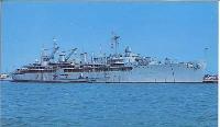
USS BUSHNELL - AS15

| Things To Do Map and Directions |
Copyright © 2010 USS Bushnell Reunion Committee
| Rhode Island Bay Cruises Approx. 16 Miles Rhode Island Lighthouses & Newport Harbor See Website for more information! |
WAIT until the entire map has been loaded
into the frame at the right before printing.
Use the cursor by placing it on the map and
holding the left button down to adjust the
map until the marked route is completely
in the frame. Click the "Print this Page"
button to get a print out of these directions.
You can also scroll to the bottom of the map
and click on "View Larger Map" to see the
original map and directions.
| Scroll Down ----> |
|